An MPA redesign and enlargement proposal for the Graciosa Island Test Site#
Q 13 - How to evaluate trade-offs in MSP and MPA designation process?
Q 13 - How to evaluate trade-offs in MSP and MPA designation process?
Q 53 - How to identify and analyze the main conflict areas between human uses and the environment?
Q 63 - How to deal with knowledge gaps on socio-economic data, including the spatial dimension?
Q 63 - How to deal with knowledge gaps on socio-economic data, including the spatial dimension?
Description#
Introduction The proposal for Graciosa Island emphasises the application of Criteria for the representation of the social and economic dimension of MPAs (ESE2) and Trade-offs method for protections and restoration in MSP and Nature-inclusive operation of blue economy sectors (ESE3) in developing a new MPA management strategy. The final outcome was: to present a proposal for an IUCN category VI iMarine Protected Area (MPA), involving the redesign and expansion of a previous existing MPA. The new design space will protect biodiversity while promoting sustainable fishing and tourism activities in the region.
**Collaboration with the Local Community **
One of the project’s results was the co-creation of a new map, including fisheries management zones, developed in collaboration with local stakeholders. This involvement was fundamental, as the Graciosa community emphasised the wish for co creation and the importance of good management practices in MPAs. These practices are essential for the effective protection of marine resources and the maintenance of environmental quality while ensuring the local community keeps its traditional use of the ocean.
Importance of Participatory Management
Integrating effective management practices, promoted through the co-creation with all the agents with an interest in marine management, strengthens the community’s confidence in conservation initiatives. This approach not only improves awareness of the importance of MPAs but also emphasises the shared responsibility for protecting local ecosystems to maintain their traditions in place in a sustainable way.
Participatory Mapping
SeaSketch was a vital tool for participatory mapping in this case and in the Azores in general, offering an innovative platform for marine planning and management that enhances stakeholder engagement. By enabling users to clearly and immediately visualise map data, contribute with spatial information, and collaboratively design zoning scenarios such as MPAs, SeaSketch facilitates informed decision-making and promotes shared visions for sustainable ocean management. The Azores’ unique marine environment benefits from SeaSketch’s ability to integrate diverse datasets (as the ocean Uses Survey to support Azores MSP) and provide advanced geospatial analysis, ensuring that planning processes are inclusive, efficient, and tailored to the region’s ecological and socio-economic priorities.
Calado, H., Gutierrez, D., DE Bruyn, A. (2025). Navigating Trade-offs on Conservation: the Use of Participatory Mapping in Maritime Spatial Planning. Npj Ocean Sustainability 4:8 (2025). DOI: https://doi.org/10.1038/s44183-025-00109-6
Queiroz, J., Gutierrez, D., Calado, H. (2024). Trade-Offs in Marine Policy Decisions Through the Lens of Literature. Oceans 2024, 5, 982-1007. DOI: https://doi.org/10.3390/oceans5040056
Resources#
Fishing management zones
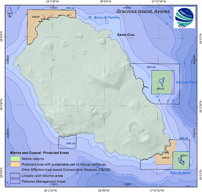
Updated map of fishing management zones, developed in collaboration with the community.