Prioritization and optimization for the identification of strictly protected Belgian MPAs#
Description#
Application of the area prioritization and optimization tool (ABC planner) for the identification of strictly protected Belgian MPAs
Introduction
The MSP4BIO Belgian Part of the North Sea test site focused on identifying priority areas to be considered for strict protection to align with the requirements of the EU biodiversity law (10% strict protection). By using the ABC Planner tool (Kotta et al. 2024), an area prioritization and optimization analysis was implemented to identify zones for strict conservation, while considering the many other activities that take place in the BPNS.
Since the new and third MSP (2026 – 2034) in Belgium is currently undergoing finalizations, new proposals cannot be integrated anymore. The proposed planning solution will be used as a validation step where the resulting zones from the prioritization and optimization analysis can be compared to the proposed MPAs and nature restoration areas for the third MSP.
Human pressures identified by trade-off scenarios
To highlight the importance of current nature conservation zones (Natura 2000 MPAs), Special Areas of Conservation (SAC) were treated as valuable sandbanks in the ABC planner analyses. Additionally, focus was given to potential marine reserves with a higher degree of connectivity. Based on a trade-off analysis that was performed during one of stakeholder workshops using the SeaSketch tool, and available data layers for the BPNS, the following human pressures were used in the ABC scenario analysis: offshore renewable energy, maritime traffic, and fishing intensity.
For offshore renewable energy both current and future concession areas were included, with a higher emphasis on the current concession zones. For maritime traffic, shipping density data was used to identify high-traffic shipping areas (data from 2023 for all vessel types). Lastly, as most significant fishing-related impacts in the BPNS are likely caused by benthic trawling, only those trawling areas with more than five hours of activity were included. The distribution and intensity of these human activities was explicitly considered to avoid establishing conservation areas in locations where high pressures would compromise their effective establishment.
Nature valuation included for the analysis
In the ABC planner, the existing nature value (NV) targets were set to 30% of the total protected nature assets, which resulted in just over 10% of the total Belgian EEZ being protected. For biological nature values, the focus was on benthic species. Habitat suitability maps of five key ecological macrobenthic species were used (Abra alba, Magelona-Ensis, Hesionura elongata, Nephtys cirrosa, and Macoma balthica). Sandbanks were restricted to binary values (0 for absence and 1 for presence), and all invertebrate data were normalized to a 0-1 scale. These normalized maps were then averaged to produce a single infauna map, ensuring the habitat’s value was better integrated into the analyses.
Marine reserves proposed through the area prioritization and optimization tool
The proposed marine reserves, covering roughly 10% of the BPNS correspond partially to those proposed for the new MSP (± 4% of the BPNS). The smaller area located furthest offshore identified by the ABC planner corresponds quite well to the offshore zone proposed for the third MSP (2026-2034). The biggest area identified with the ABC planner overlaps mainly with the new concession zones. Although this area corresponds to ecological important habitats with high biological value, as was evident from the nature valuation, the new concession zones have been approved and will be implemented during the third MSP for the BPNS. Only a very small part of this biggest area identified by the ABC planner overlaps with one of the newly proposed zones for the third MSP. Unfortunately, that part also covers heavy traffic lanes. The most coastal zone that was identified by the ABC planner is located right next to the coastal area proposed for the third MSP. The difference between these zones is a trade-off between fishing intensity and natural valuation. The zone proposed by the ABC planner avoids the higher fishing intensity zone while the zone proposed for the third MSP covers an area with a higher biological value.
For a second scenario run with the ABC planner stricter thresholds could be applied on the human uses and trade-offs, and more biological data could be added for nature valuation (e.g. Lanice conchilega habitat suitability map and pelagic fish distributions). The results here clearly demonstrate the value of tools like the ABC planner in guiding the designation and optimization of area-based protection measures in regions with a high concentration of human activities.
Resources#
Marine reserves identified with the ABC planner
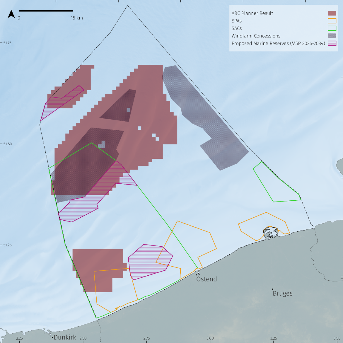
Map showing the proposed marine reserves (dark pink) identified with the prioritization and optimization analysis using the ABC planner, while the marked areas in purple show the proposed marine reserves for the new MSP (2026-2034).
Public consultation on the marine spatial plan for the Belgian part of the North Sea (2026-2034), maps and the accompanying strategic environmental impact assessment are available at: https://www.health.belgium.be/nl/openbare-raadpleging-over-het-marien-ruimtelijk-plan-voor-het-belgische-deel-van-de-noordzee-2026