Deep-sea ecosystems conservation strategy in the North-Western Mediterranean: a blueprint for 10% of#
Description#
Introduction
The North-Western Mediterranean test site objective was to identify some conservation priorities to guide the expansion and increase the efficiency of the current Franco-Italian transboundary Marine Protected Areas network .In particular, it aims to start to integrate climate change scenarios and potential shifts in ecological responses in MSP by identifying needs to support a better planification of knowledge acquisition necessary to decision making and management efforts. Finally, it endorsed the political target of designating 10% of strictly protected areas (SPZ), applied to the deep-sea ecosystems and considering marine mammals and benthic habitats as indicators of outmost importance, both for their value as biological indicators of good environmental status as well as ecological features receiving prominent political attention. The approach will be precautionary in the sense that it will propose areas under protection even if not all knowledge is available.
Inputs include meetings with the Communities of Practice (CoP) in Italy and France, interactions with experts, the analysis of the existing planning documents and, on the French side, of the public debate for the revision of the maritime spatial plans, which took place from November 2023 to April 2024.
Scoping
Management question: how to set up 10% of strictly marine protected areas contributing to the good environmental status of marine ecosystems
Management objective: conservation of deep-sea ecosystems
Management approach: selective
Context scale: at MSP level
**Geographical area:* NW Med with more than 200m depth. It concerns the French vocation map sectors n°1, 18, 19, 20, 21, 27, 28, and the Italian maritime spatial plan sub-areas MO/8_01, MO/8_02, MO/8_03 and the Northern half of MO/11_01.
Temporal scale: mid- and long-term
Human uses: fisheries, maritime traffic, deep prospection
Human pressures: pollutions, noise, abrasion and resuspension of particles, extraction of species, invasive species, animal disturbance and collision, fishing
Ecological toolkit: * bio-ecological target: deep-sea habitats, marine mammals, as species engineers (habitats formers) and indicators of vulnerable ecosystems * species - ecosystems priorities for conservation: European Habitats Directive Annex I, II, IV; SPA/BD Protocol Annexes II-III: list of endangered or threatened species; General Fisheries Commission for the Mediterranean Vulnerable marine ecosystems’ indicator features, habitats and taxa, FAO * macro-criteria: vulnerability, functional hotspots, life cycle critical areas, climate smart potential
Data collection and presentation
A map viewer with a selection of information has been set-up specifically for the North-West Mediterranean test site (Map viewer MSP4BIO) for the implementation of participatory mapping (being filled in). A story board (NORTH WESTERN MEDITERRANEAN SEA | MSP4BIO) presenting what is at stake has been developed to inform the general public and raise awareness. The selected information includes areas already identified as important for nature under different environmental policies: Natura 2000 sites and other marine protected areas, Important marine mammals areas (ACCOBAMS), ecologically and biologically significant areas (CBD), and all Vulnerable Marine Ecosystems information available to date. Other main data sources displayed are Marine mammals density observed from aerial surveys, marine mammals species diversity referenced in OBIS sea-map, expert knowledge about Ziphius and Sperm whale preferential areas, and Chlorophyll A mass concentration from Copernicus Marine Service.
Activities considered are fisheries and maritime traffic. Impact of fisheries is represented through AIS information from European trawlers more than 15m long. Maritime traffic is synthetised using AIS data and showing the main routes for the different types of traffic.
Analysis and diagnosis
The analysis relied first on observations data and previous identification of areas of interest. It resulted in six large areas of interest: the slope of the continental shelf in the gulf of Lion, the coastal area from Port-Cros to San Remo, the gulf of Genova, the North-West of Corsica and two large areas far offshore, significant in terms of density of marine mammals and Chlorophyll A mass concentration observations.
Additionally, three areas of particular interest either due to strong cumulative evidence supporting protection or significant public concern expressed during consultations were identified: the Western part of the gulf of Lion canyons, the Var canyon and the San Remo canyon.
Overlaying these areas of interest with activities of fisheries and maritime traffic shows most interactions with fisheries in the western part of the Gulf of Lion, and with maritime traffic in the Eastern part of the Gulf of Lion, as well as in North-West and West of Corsica.
Connectivity: the main drivers are general currents from East to West along the slope of the continental shelf. It stresses the importance of eastern sites and of having regular steps toward the West. The designation strategy should then have the precaution to include an East-West profile.
Climate change adaptation will depend notably on three conditions: the connectivity at the scale of the sea basin, a large range of depth in a single site to allow distribution shift along the slope, a large range of North-South and East-West areas.
Prioritization and designation
Existing maritime spatial plans in France and Italy already decided general priorities in their vocation maps. They are used to give weight to environmental arguments in the trade-offs compared to other socio-economic criteria. Somehow, it is key to modulate the 10% target per zone. Additionally, In France, the public debate “la mer en débat” (November 2023-April 2024) organised by the National Council for Public Debate, in support to the revision of the maritime spatial plan, focused notably on the development of strictly protected areas. Participatory mapping was organised both through an Internet platform and during public workshops. The synthesis drawn by the National Commission endorses priorities for coastal areas (including deep sea features in Corsica and Côte d’Azur) and the importance of the slope and canyons of the gulf of Lion. It also proposes to look at the contested area between France and Spain as an opportunity for a joint protection initiative, partly under strict protection (noting it includes the western canyons).
As a first step, we propose, a network of seven large nature reserves, which demonstrate the possibility to reach the 10% target and could serve as the basis for the next round of discussion between decision-makers and stakeholders. The principles followed to identify potential strictly protected areas were the following:
located in the areas of interest and if possible, of particular interest
avoiding when possible, interactions with existing activities
giving a higher priority to nature protection where the maritime spatial plans are doing so
valuing the conclusions of the public debate
taking into account existing strict protection (National Parks of Port-Cros and Calanques, Bonifacio Strait International park)
looking for synergies with other existing marine protected areas as well as with terrestrial protected areas connected with the marine compartment to ensure a better inclusion of the land-sea connectivity and protection effort
as well as existing other effective conservation measures (namely the Fisheries Restricted Area Gulf of Lion and the Particular Sensitive Special Areas Strait of Bonifacio and North-Western Mediterranean)
considering large areas (if possible more than 1000 km2 large)
having a West-East and North-South coverage
Conclusion
The proposed network is answering to the 10% target in the realm of deep-sea ecosystems by combining available information and taking into account socio-economic criteria as well as public consultation inputs and already decided maritime spatial priorities. It constitutes a step toward the designation of strict protected areas. It could be involved in maritime spatial plans as areas where the possibility of designating a Nature reserve should be put under study, keeping in mind the benefit expected from the designation of the whole network. Additional information and consultation are necessary to reach the final designations under the proper legal status: notably inventories and surveys for more precise habitat mapping and activities appraisal, and discussion with stakeholders directly concerned.
Resources#
Network of strictly protected areas
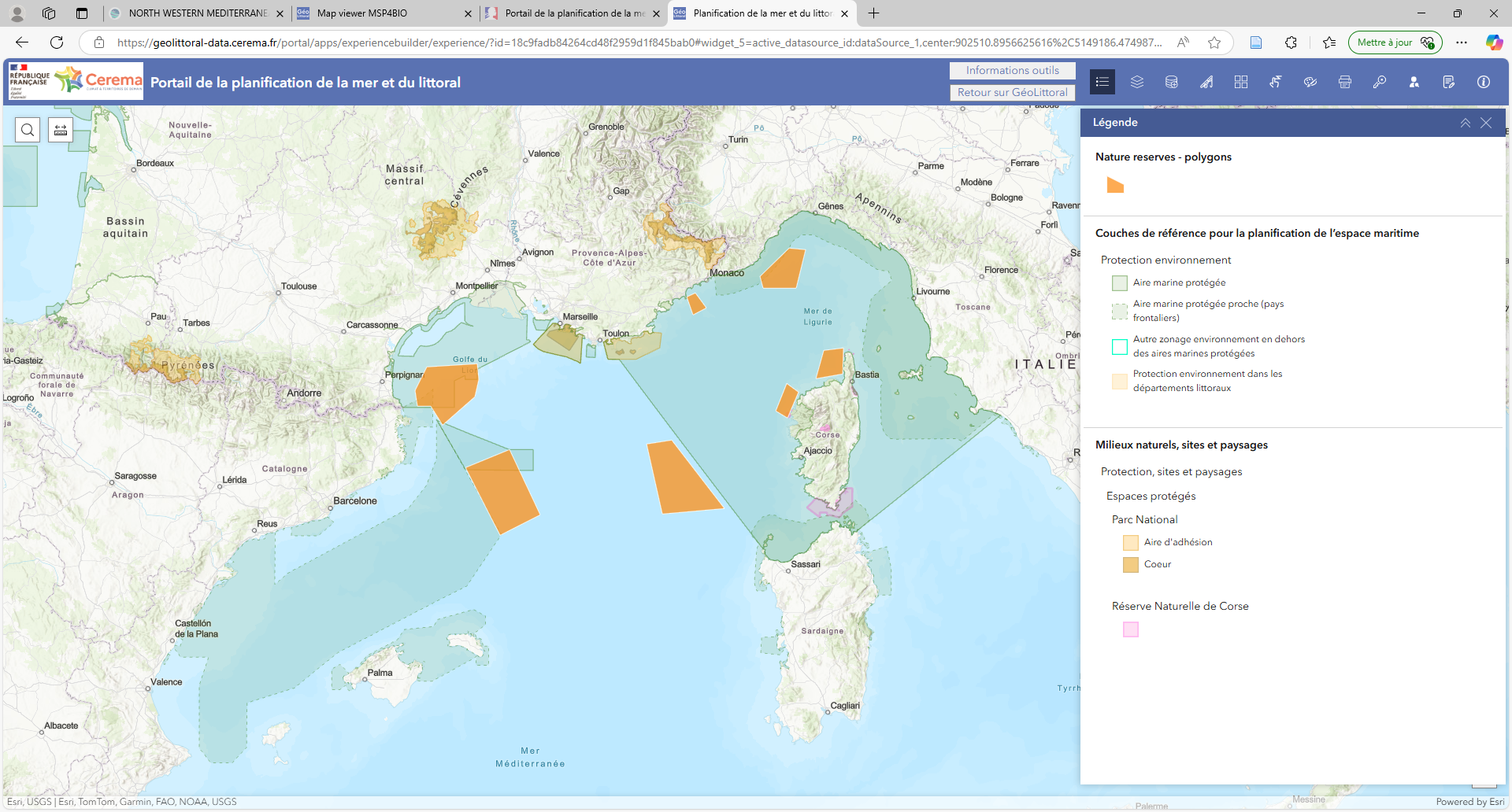
The resulting network of strictly protected areas for deep sea ecosystems: seven new Nature Reserves, two National Parks and the Bonifacio Straight Nature Reserve; in light green: other existing marine protected areas
Proposed nature reserves
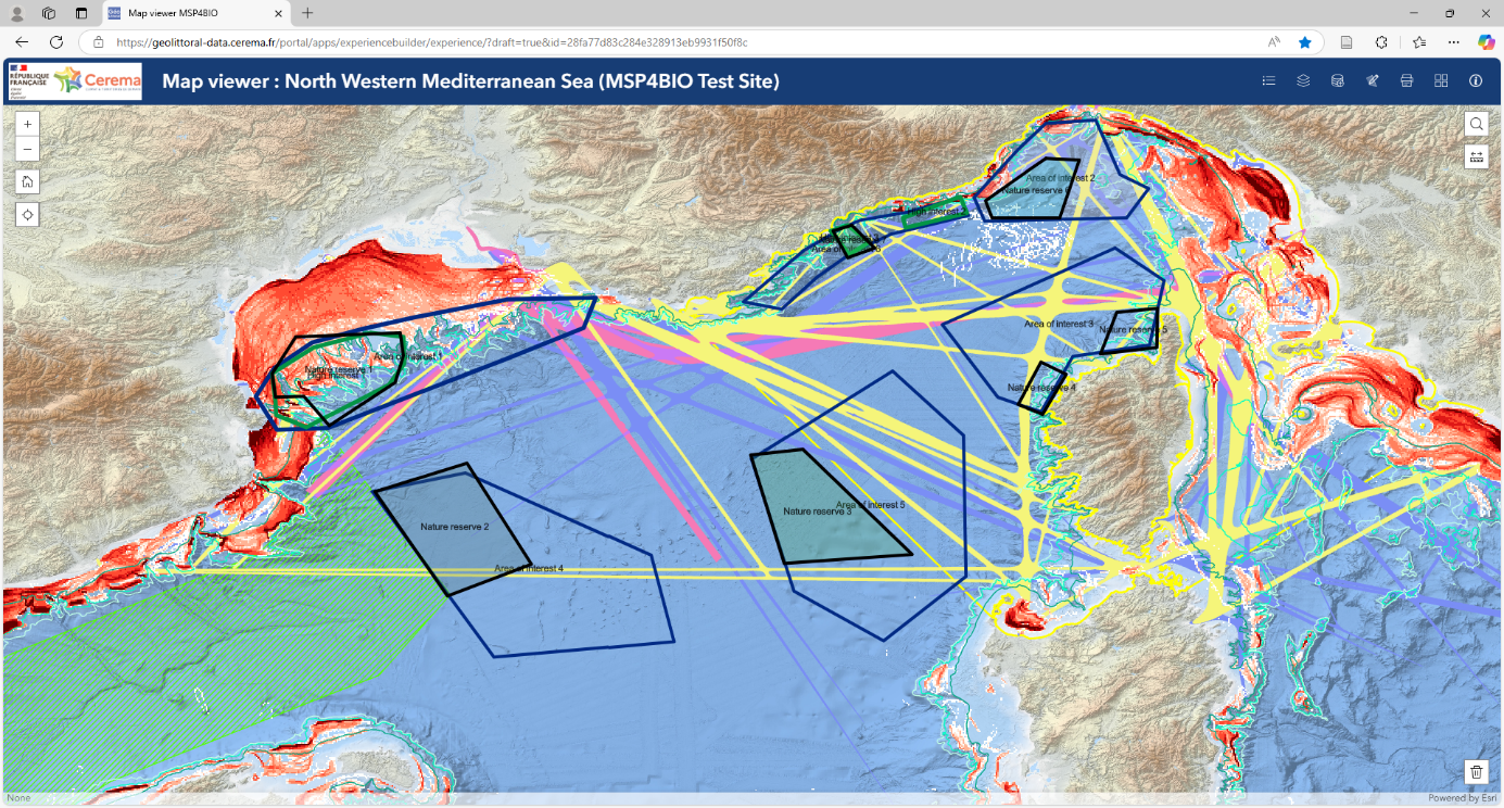
Black polygons are the proposed nature reserves, compared to « areas of interest » (blue polygons), « areas of upmost interest » (green polygons), main maritime traffic roads and bottom trawling fishing grounds
MSP in France and Italy
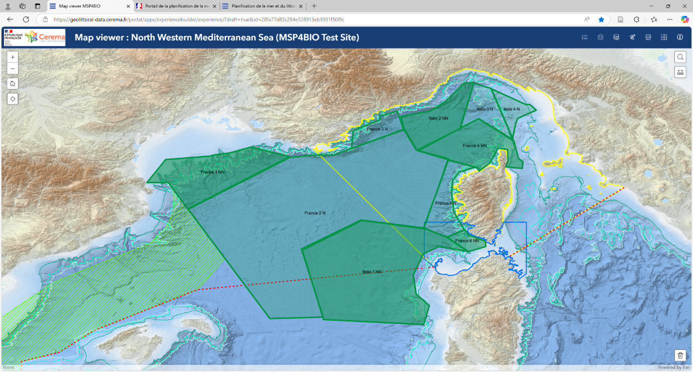
Maritime spatial plans in France and Italy: priority given to nature in two levels (N and NN); the spanish cetacean corridor is mentioned on the map
Areas of interest
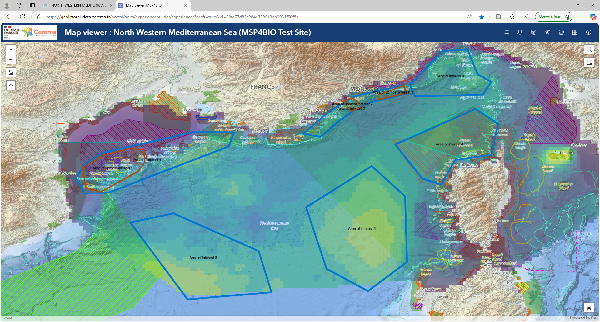
Areas of interest (blue polygons) and of upmost interest (red polygons), compared with existing marine protected areas, observed vulnerable marine ecosystems and density of marine mammals observations (SAMM aerial surveys)